INTRODUCTION
Climate change is one of the biggest challenges facing the planet in the present time, and the individuals and communities who face being displaced from their homes and lands due to climate change are the human faces of this tragedy. Population displacement associated with natural disasters as a global issue. The significance of climate change-induced migration, including those resulting consequences from natural hazards and disasters, has increasingly drawn devotion from academia and policymakers. Extensive natural disaster identified Bangladesh as the most high risk and disaster-prone country. Bangladesh was the 3rd rank top country for displacement due to natural disaster event in 2017. Between 2008 and 2016, it is estimated that 4.7 million people were displaced due to disasters in Bangladesh. As climate change leads to more frequent and intense natural hazards, it is expected that the climate displacement problem is increasing day by day in Bangladesh. Climate change is expected to affect the people displacement in Bangladesh from their living home and land in at least four ways: (1) The escalation of natural disasters both rapid and slow-onset leading to increased displacement as well as migration; (2) the adverse consequences of increased warming, climate variability and of other impact of climate change on livelihoods, health, food security, and water availability; (3) rising sea levels which create coastal areas uninhabitable; and (4) competition over limited natural resources potentially leading to increasing tensions and even conflict and, in turn, displacement.[1-3]
Bangladesh is widely recognized to be the worst victim of climate change. The primary sites of displacement in Bangladesh occurred in the coastal regions and the river delta regions in the mainland. Of Bangladesh’s 64 districts, 26 coastal and mainland districts are already producing climate displaced people: It is estimated that 6 million people have already been displaced by the effects of climate hazards in Bangladesh.[4,5] The Bangladesh Climate Change Strategy and Action Plan (BCCSAP) estimates displaced people may exceed 20 million by 2050 while recent studies show that the number is likely to be more than 35 million. In fact, more than 1 million people have already lost their homes, and 70% of them became displaced persons by only river erosion.[6] In terms of addressing climate change migration and displacement, the BCCSAP (2009) states that “migration must be considered as a valid option of the country. Preparations in the meantime will be made to convert this population into trained and useful citizens for any country,” suggesting the aspiration that such displaced people become “useful citizens” by moving abroad. While it is initially positive that migration is viewed as an effective and positive response to the effects of climate change, this broadly reflects the narrow policy of Bangladesh in that people displaced by climate change should migrate internationally, rather than within Bangladesh.[6]
From the study, it was found that nearly 46% people temporarily displaced and 12% people permanently displaced due to different hazards in four climate hotspots of Bangladesh.[7] Therefore, some dispute that adaptation practices should focus on the most vulnerable groups or those with the climate displaced people. Adaptation is rising as a key policy response for reducing the adverse effects of climate change, and to protect the livelihood and forced to displacement.[8] However, poor households’ local adaptation strategies are often overlooked and not included when developing adaptation strategies. Actions like government intervention are crucial in ensuring sustainability of adaptation for protect the coastal inhabitants from losing housing, land, and property assets of the poor communities farm-level adaptations of the poor farmers.[9]
Different adaptation practices including technological measures, behavioral approach, managerial advances, and policy are carried out in the coastal area of Bangladesh. Most of the coastal inhabitants practiced community-based adaptation strategies for reducing the impact of natural disasters. Adaptation must accomplish the criteria to gain sustainable development and also must be evaluated based on mainly effectiveness in risk-reducing, economic feasibility, and social acceptance. In response to the regular and severe natural disasters, Government of Bangladesh has developed a number of programs to relocate and rehabilitate people who have been made landless and homeless as a result of different slow and sudden onset disasters. These programs are known as Agriculture Khas land distribution to landless families, Adarsha Gram/Cluster Village, Gucchagram or Climate Victims Resettlement Project, Abasan and Ashrayan project for ensuring housing to landless and homeless people of all over Bangladesh but the migration of displaced people to big cities increasing day by day.[10]
From the different study, it was found that existing resettlement program has been accelerated a lot of negative things such as displaced people specified the society, create social stratification, built mythological ideas, facing local political and Mussel man violence, facing economic crisis because nobody trust him, feeling psychological stress, loss of social, cultural norms, and value and so on. As displaced people’s lifestyles are very different from the local settlers, they are not accepted so easily in the community. Displaced people are deprived of their rights, dominated by the local people, threatened and afraid and victimized for their marriageable off-springs. They often face an identity crisis as well. Local people tend to show unwilling behavior when the displaced people send their children for education. They are deprived of basic and urban amenities.[11] From this point of view, the prime purposes of the study are to assess the displacement pattern of the island dwellers addressing the adaptation practices of coastal communities as sustainability point of views for protect themselves against climate change induced displacement vulnerability.
MATERIALS AND METHODS
Study Area
To conducted the study, authors have been selected south-eastern coastal zone of Bangladesh particularly three Islands namely, Maheshkhali, Kutubdia, and Sandwip. Climate susceptibility, displacement rates, land erosion, and recurrent disaster have been considered during the selected for the study. UK based world famous newspaper The Guardian published the erosion status of Kutubdia where it was highlighted that due to the impact of climate change, sizes of Kutubdia Island reduced almost 50% in past 20 years. Since 1991, six villages on the island completely have gone to the sea, and about 40,000 people have fled, and most of them got temporary shelter to the coast near Cox’s Bazar.[1]
Barua et al. (2017) stated that cyclonic storm surge causes huge life and property losses for the people of Kutubdia, Sandwip, and Maheshkhali islands. The rate and numbers of people displacement mainly occurred in the study through the cyclonic storm. There are 30 cyclones outbreak in the Bay of Bengal which has caused significant damages to lives and properties of the study areas. There are 5,74,000 people forced to displaced from their home and land in south-eastern Bangladesh due to the cyclone attack from 1960 to 2016.[12,13]
The Sandwip Island belongs to Chittagong district with an area of 762.42 km2. Kutubdia Island belongs to Cox’s Bazar district with an area of 215.8 km2 which is bounded by the Bay of Bengal. Maheshkhali Island is another coastal island belongs to Cox’s Bazar district with an area of 362.18 km2 that is also bounded by Bay of Bengal. Three islands are created by tidal, supra-tidal, and fluvial processes of Ganges river particularly topography is mudflat, sandy, and gentle slope [Figure 1].
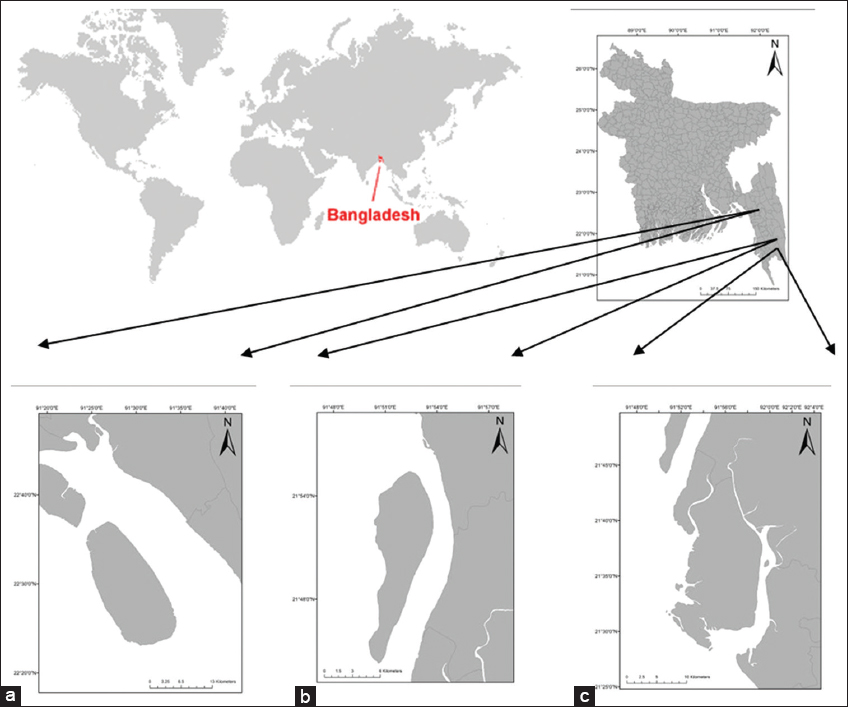
Figure 1: Geographical location of the study areas. (a) Sandwip Island, (b) Sandwip Island, (c) Kutubdia Island
Data Collection
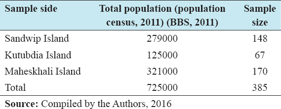
The interviews for data collection among the communities who originally displaced due to climate change induced natural disasters from their living land and home at least 1 time in their life. The study was primary or field data based, but some of the secondary data have been used. Both qualitative and quantitative approaches have been applied. Qualitative data have been documented through participant observation, key informant interviews (KII), and focus group discussion (FGD) methods. In general, quantitative data were gathered through questionnaire survey method respectively. A total of 8 KIIs were interviewed, among 2 were done with Additional Deputy Commissioner-Revenue, 2 with union chairmen, 2 with journalists, 2 with Upazila chairmen and Upazila Nirbhahi Officer at the study area. A total of 6 FGDs were completed among the displaced communities for assess their opinion about the problem and possible solution of rehabilitation crisis. During the discussion, each 15 women were present in every FGD in the study areas. Besides, total 385 numbers of questions were operated in three Islands for the coastal communities. The sample size of every Islands divided through based on Island populations [Table 1].
Table 1: Determination of sample size among three study areas
The questionnaire for household survey were designed for give the priority on causes of displacement, pattern of displacement, time and duration of living of displaced people and existing rehabilitation program of displaced people in the study area.
A semi-structured questionnaire has been applied for the quantitative data collection. Sampling frame has been developed after collection of the total population in both study areas. The sample size has been chosen in line with a statistical formula:[14]

Where n0= desire sample size, z = standard normal deviate usually set at 1.96, which corresponds to the 95% confidence level (z = 1.96), p = assumes proportion in the target population estimated to have a particular characteristic (P = 0.5), q = proportion of the estimation of population (q = 1-p), d = allowable maximum error in estimating a population proportion (d = 0.05).
Sampling Design
Simple random sampling technique was adopted for successfully operating of 385 questionnaires at a household’s level of the displaced people [Table 1]. Considering the representative sample size, the authors have distributed those samples in the three study Islands, respectively, on the statistical way with the help of following formula;

Where, Nj = represents the sample size, N = total population size, (N = ni + nii + niii +……+ nn), Ni = population size of study area, n= desired sample size.
Data Analysis
After collections of both qualitative and quantitative data from primary and secondary sources, these data were edited, coded, classified, and tabulated the sequential manner. Qualitative data were examined with the help of narrative analysis. Quantitative data were interpreted with the help of two analyses such as - statistical analysis and analytical analysis. Statistical and analytical analysis of the study was done with the help of statistical techniques, especially (Statistical Package for the Social Sciences: version-16).
The authors explored the natural hazards occurred in the three study Islands that responsible for displacement from the household survey and make the relationship with the hazards and different sectors related on coastal communities. After that authors figure out the data on time of displacement, duration of living places, and pattern of displacement of climate displaced people in the study area through data analysis.
The authors then identify the Government rehabilitation projects in the study Islands through KII and FGD in the targeted communities. Then, the authors were taken interviews with beneficiaries of rehabilitation projects such as Ashrayan, Abasan, Guchogram, and Adarsha village through semi-structured questionnaire for assess the status of the rehabilitation. After the finding of the study, the authors proposed the sustainable rehabilitation approaches for resolve the predicament of resettlement for climate displaced people in the study areas which will be model for all over Bangladesh.
RESULTS AND DISCUSSION
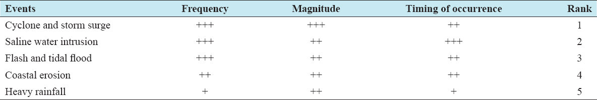
From the finding of the study, the authors noted that three coastal Islands affected frequently by cyclone and storm surges, tidal floods, coastal erosion, and saline water intrusion which are creating responsible for forced displacement of coastal inhabitants. According to the household survey, communities stated that cyclone is the major devastating and climate-induced disaster in Island areas. Its severity and magnitude are very high, but duration is short. Salinity intrusion damaged the agriculture field through the damaged embankment and also storm surges, tidal flood during the cyclone occurred and heavy rainfall time. The coastal communities also stated that coastal erosion is one of the major causes of displacement in the study island which was occurred due to the damaged embankment, land submerged into the sea and happened during the rainy season every year [Table 2].
Table 2: Frequency, magnitude, timing of occurrence and ranking of natural hazards in coastal area
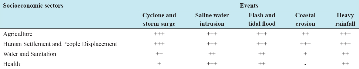
The authors prepared the relationship between natural disasters and different sectors around the communities of the study areas through household survey explored in Table 3. From Table 3, it was found that cyclonic storm surges damage their homestead, livestock, agriculture crop, livelihood, drinking water availability, sanitation, and health. Unpredictable coastal erosion is the main community risk and is creating pressures to the key communities such as agricultural farmers, crop farmers, and wage labors. Using the process described above, the risk ranking for the identified hazards, responsible for creating climate displaced people for study areas. Based on the combined risk values for the probability of occurrence and impact to Sandwip, Maheshkhali, and Kutubdia Islands and the result also highlighted that all the natural hazards mostly affected human settlement and displacement of the mass population followed by agriculture, water, and sanitation sectors [Table 3].
Table 3: Relationship between natural hazards and socio-economic sectors
Displacement Behavior of Islanders
From the survey, the authors found that natural disasters differ significantly in their potential to originate climate displacement for the communities. The authors illustrated that due to numerous natural disasters; communities of the study areas have experiences of three patterns of displacement in their life which generally (1) temporal displacement, (2) permanent local displacement, and (3) permanent internal displacement around Bangladesh. From the survey, the authors found that Kutubdia and Sandwip people leave his origin habitually to out of own Upazila and Maheshkhali people migrate customarily to out of individual union. The results of the pattern of displacement are presented in Figure 2.
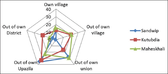
Figure 2: Pattern of displacement in Island areas
From the survey, the authors identify that most displaced people acquired shelter in diverse areas such as Government Khas land (roadside without formal permission), government land (with temporary ownership from second parties), on the coastal embankment. These people made temporary houses on both sides of the embankment, and few respondents remake their houses on their individual land. It was found that livelihood and living situations of study areas inhabitants are Nomadic’ nature and so vulnerable for their life. Due to weak embankment and strong wave, Sandwip people habituated for unstable their houses frequently. Hence, inhabitants of Sandwip not able to stay more than 2 years endlessly compare to other two Islands [Figure 3].
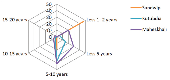
Figure 3: Duration of respondent present living place
From the data of Figure 4, the authors explored that Sandwip people mostly displaced from their home and land more than 8 times, Kutubdia peoples displaced 6–8 times and Maheshkhali peoples have experienced for displacement of 4–6 times. These finding highlighted that communities of the disaster-affected study areas could not be able to recuperate, and generation to generation stand the travails of this ill-fated. All the respondents of the study areas have experienced for displacement problem due to cyclone, coastal erosion, tidal surges, and other disaster from 1 to 20 times.
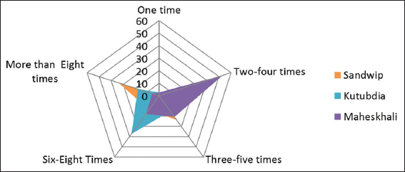
Figure 4: Time of displacement of Island dwellers
From the finding of the study, the authors stated that island inhabitants prepare their houses with locally existing woodcraft, artesian using wood, bamboo, CI sheet (tin), and other thatching ingredients. Coastal communities believe that the are where coastal embankment are covered by mangrove afforestation are free from coastal erosion and for this reason they ranked higher position for coastal embankment cum afforestation program as adaptation practices. However, it also found that coastal afforestation is customarily under tremendous pressures due to illegal grazing, illicit tree felling, and forest land encroachment led by influential people tend to serious damage of plantations.[15] This is occurred due to the unplanned expansion of shrimp and salt farming around the mangrove forests with embankments totally vanished by the communities of study areas. As a result during the natural disaster occurred in the study areas, high level of tidal and storm surges certainly abolish the damaged and week embankment and flooded the community living places and uprooted the houses.
The authors found that coastal Island dwellers planted the important trees around their homestead for own existence. They also construct the house in short height and increased the platform level of the houses. Sometimes, they planted the locally available grass for protect the houses and land from submerge the flood and free from coastal erosion. This adaptation practices by the study areas inhabitants ranked as high categories due to environmentally, economically, and social perspective these practices become sustainable and successful adaptation for the respondents.
The authors strongly prescribed in the paper for “Community Based Rehabilitation options” for the solution of resettlement crisis of the climate displaced people in the coastal areas of Bangladesh. This study strongly proposed non-specialized rehabilitation options, such as “community-based rehabilitation program;” however, rehabilitation practices by the Government of Bangladesh such as “Gucchogram,” “Ashroyon,” “Abason,” and “Adrasha village” are discouraged. From the study, it was found that existing Bangladesh Government rehabilitation program has been enhanced a lot of negative effects such as displaced people specified the society, generate social stratification, erected mythological thoughts, living in threat of local political and Mussel man violence, suffering economic crisis because local people not trust them, feeling psychological stress, loss of social, cultural norms and values, and so on. The people are destitute from their rights, ruled by the local communities, threatened and afraid and lastly victimized for their marriageable off-springs. Regularly climate displaces people suffering identity crisis as well in new living places. Local people tend to show unwilling behavior when the displaced people send their children for education. They are underprivileged of basic and urban amenities.[7] Hence, consider the above problem and reality, the authors recommitted for displaced people rehabilitation options should be rehabilitate in a local community places so that they can be known and create their legal representative and welfare committee. This resettlement area should need to safe and stay beside other functional and commercial areas. Figure 5 illustrated the two categories of holistic approaches such as “top-bottom” and “bottom-up” approaches.
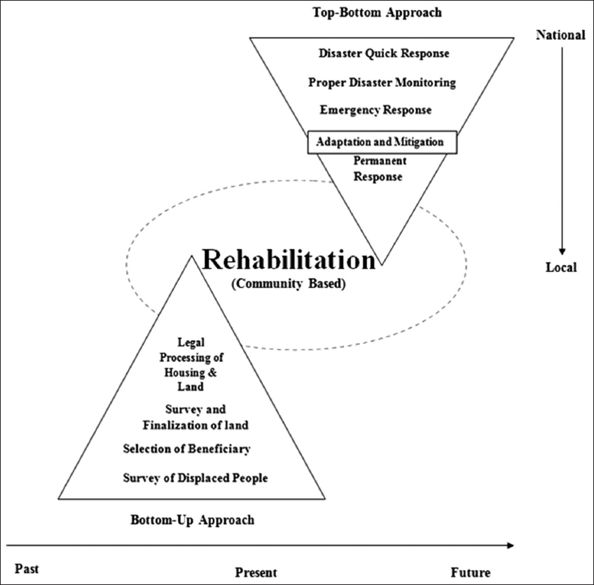
Figure 5: Holistic approach for ensuring the “ community-based rehabilitation program”
The reintegration of livelihoods for the coastal inhabitant after the climate change induced disaster outbreak should be seen as an opportunity to strengthen the community-based rehabilitation options for resolve displacement problem for the helpless and landless people. The authors recommended that the focus of rehabilitation efforts should be on rebuilding the economic basis of livelihoods rather than on physical reconstruction, and on giving coastal people the skills and resources for self-recovery of displacement problem and migrated to other places. This study highlighted about the joint involvement of public and private sectors for sustainable livelihood based rehabilitation efforts, seeking out and creating opportunities for both economic and social development. This resettlement action is recommended for the climate displaced people to resettle inside the community living places and for that reason they could be known and create their legal representative and welfare committee. This approaches should pave the way for them to be united and strong and finally, they are being capable for protect themselves from any exotic violence and disturbances. This resettled area should be safe and stay beside from other functional areas [Figure 6].
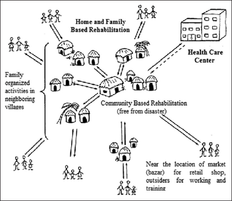
Figure 6: Thematic concept about “community-based rehabilitation program”
The authors prescribed that the bottom-up approach significantly denoted long term and slow process of rehabilitation approaches for climate displaced people. The study recommended for always need to required four management stages such as a survey of displaced people, selection of appropriate beneficiaries, survey, and finalization of land and legal processing of housing and land separately those are going to the proper rehabilitation of displaced people.
CONCLUSION AND RECOMMENDATIONS
The study exposed that households have somewhat responded to the cyclone, tidal flood, and coastal erosion hazards and other climate change-induced problems through adopting a range of adaptation practices that depend on their socioeconomic and household characteristics, and access to institutional facilities and social capital. The important fences to adopting the sustainable adaptation options include a lack of information on coastal erosion and related climatic issues, poor knowledge about appropriate strategies, inappropriate crop varieties, the limitations of one’s own land, and limited access to credit services. Sustainable adaptation is essentially a global issue since social equality and environmental integrity are important for all populations to achieve sustainable responses to climate change. The adaptation processes have and will generate explicit deliberation of the risks of sea-level increase in the planned planning processes of local governments throughout the study areas including the coastal area of Bangladesh.
Climate displacement is not the concern of future which already underway in Bangladesh. Climate change induced slow and sudden onset events recurrent in the coastal areas of Bangladesh and displacing hundred and thousands of people from their homestead every year. But Bangladesh has limited scope for rehabilitated mass displaced people in few rehabilitation program. As a result, huge countless displaced people forced to migrate rural to urban areas of the country and living here and there. Besides, existing rehabilitated options have been stigmatized and formed a lot of difficulties in their present living and destination places such as identity crisis, threat from local people to leave the place, lack of good relationships with local authority and land ownership, the nonexistence of cultural harmony and absence of any kind of assistances from local neighbors.
To ensure the solution of non-cooperation from local people, community-based rehabilitation approach’ not only ensures their permanent settlement but also secures their dignity, local hood, culture, society, and wisdom. Besides, ensure appropriate coordination between the Government and NGOs or development partner during the distribution of the short-term rehabilitation program, especially distribution basic needs for climate displaced people in disaster-prone areas of Bangladesh.